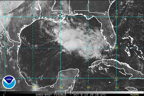
That's a satellite image of what was left of Karen as of about 11 AM today. You can see the center of circulation has moved a good bit farther west than had been predicted. The latest track this afternoon has it coming much closer to us now. However, as the center shifted west, it seems to have left most of its punch behind.
The next aircraft missions into Karen this afternoon will help determine if the cyclone has weakened to a depression. The environment remains unfavorable for intensification and most of the guidance shows gradual weakening. The new NHC forecast shows the system weakening to a depression in 24 hours. There is little difference in impacts between a 30-kt depression and a 35-kt tropical storm...and tropical storm force gusts could easily occur in convective bands. Karen should dissipate or be absorbed by a cold front shortly after 48 hours.Jim Cantore is sad.
#TSKaren remains a convectionless gale center that hardly deserves TS status. Not expecting much at this time: http://t.co/x4HeJX4FWP
— Jim Cantore (@JimCantore) October 5, 2013
By the way, I'm pretty sure Convectionless Gale Center is playing this weekend at Lost Love Lounge. They do a quiet synth-driven electric emo type thing. So if you can't make it out to Gretna Fest there's that.
Meanwhile, the Mayor and pals held another press conference.
As the day progresses, Landrieu said, residents could be lulled into a false sense of security because of the lack of any noticeable effects from tropical weather. But, he noted, problems can often come after the storm or when people let down their guard.Yesterday, the mayor stressed that we were all "leaning forward" which sounds like a thing that might actually quicken one's roll but I'm not gymnast so what do I know? Anyway we're slowing it down now.
“I myself have witnessed in the last day and a half a (higher) level of anxiety.” Landrieu said. “I would ask everybody just to slow their roll for the next 24 to 36 hours. It’s gonna be OK.”
And so is Karen.
Tropical Storm Karen has stalled in the Gulf of Mexico 130 miles south of Morgan City, but the National Hurricane Center still expects the system to move near or over portions of southeastern Louisiana tonight and Sunday.
No comments:
Post a Comment