Showing posts with label C.O.E.. Show all posts
Showing posts with label C.O.E.. Show all posts
Wednesday, August 03, 2011
Wednesday, July 06, 2011
They spit on it
All of this land is pretty much BP's now regardless of who owns it or who wants it
In other words, a (mostly)funded and greenlighted project is on hold because BP won't get its oil off the beach reminding us once again that the "It's BP's oil, it's BP's land" principle is still very much in play.
Much of the land on which the project will be built is owned by the Edward Wisner Donation Trust, which was donated in 1914 to the City of New Orleans under a 100-year trust agreement.
Much of Port Fourchon, the Louisiana Offshore Oil Port’s onshore operations; facilities owned by Chevron Oil, and a number of other oil and gas production facilities all sit on Wisner land.
Under the trust, the city receives 34.8 percent of the revenue, Charity Hospital and the state of Louisiana receive 12 percent, and the rest goes to Tulane University, the Salvation Army, and heirs of Edward Wisner. The city’s revenue is distributed through its Wisner Fund as grants for health, beautification, education and capital projects.
Lachney said senior corps officials have recommended that the property for construction of the dune and wetlands be bought, with mineral rights remaining with the original owner. But she said the corps’ New Orleans District officials are recommending instead that Wisner and the other owners grant easements that would assure the project would be protected.
Cathy Norman, executive director of the trust, said she also is in favor of an easement, rather than sale of the land.
The BP oil could be more of a problem, Lachney said.
“We cannot acquire any property if it is contaminated,” she said. “Any property, before we acquire it for a project, would have to be cleaned.”
Wisner officials have been trying to get BP to clean its property since the first oil washed ashore weeks after the April 20 accident, Norman said. At the moment, cleanup operations by contractors working for the joint BP-Coast Guard oil spill cleanup program are on hold because of nesting birds, she said.
But Joel Waltzer, an attorney representing the trust, said BP officials seem to be waffling on how clean they plan to make the Wisner property.
“We’ve been told now that the removal is stagnant and that the Unified Command seems content to leave oil on the beach, against our will,” he said. “To the extent any of this jeopardizes critical restoration projects, that needs to be changed.
Graves agreed. Last week, he complained to a congressional committee about the slow pace of cleanup efforts and their potential to delay a raft of restoration projects.
“The reality is that there’s oil in the Gulf today, and we likely will see oil washing up from these submerged oil mats and other sources for several years,” he said. “To say we can’t do restoration anywhere where there’s oil would mean we wouldn’t build restoration projects for years in coastal Louisiana and that’s obviously not an option.”
In other words, a (mostly)funded and greenlighted project is on hold because BP won't get its oil off the beach reminding us once again that the "It's BP's oil, it's BP's land" principle is still very much in play.
Friday, May 13, 2011
Morganza to open within 24 hours
Fallout maps here.
This afternoon I took some more pictures down by the French Quarter riverfront where the water has clearly come down about a half a foot in the past few days.
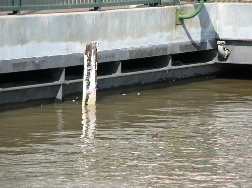
Here is the river gauge at the Natchez steamboat landing. The glare is a bit much but the gauge is stained up to about the 16 ft mark. The water below it has recently come down.
In 1927 an unelected cabal of New Orleans banking and business interests decided to have the levee dynamited below the city at Caernarvon thus flooding out people in Plaquemines and St. Bernard. It wasn't necessary to do this, of course, but the cabal couldn't pass up the opportunity to demonstrate to out of town investors that the city's fathers would do whatever it takes to protect their money.
And that shouldn't surprise anyone who pays attention. In the wake of last year's disaster, for example, the city fathers behaved much the same way by making image their primary concern. We'd like to think the same kind of thinking doesn't bleed into the Corps' decision matrix regarding the spillway but these things are never so neat.
This afternoon I took some more pictures down by the French Quarter riverfront where the water has clearly come down about a half a foot in the past few days.
Here is the river gauge at the Natchez steamboat landing. The glare is a bit much but the gauge is stained up to about the 16 ft mark. The water below it has recently come down.
In 1927 an unelected cabal of New Orleans banking and business interests decided to have the levee dynamited below the city at Caernarvon thus flooding out people in Plaquemines and St. Bernard. It wasn't necessary to do this, of course, but the cabal couldn't pass up the opportunity to demonstrate to out of town investors that the city's fathers would do whatever it takes to protect their money.
And that shouldn't surprise anyone who pays attention. In the wake of last year's disaster, for example, the city fathers behaved much the same way by making image their primary concern. We'd like to think the same kind of thinking doesn't bleed into the Corps' decision matrix regarding the spillway but these things are never so neat.
Tuesday, May 03, 2011
Dynamiting levees
Just a reminder. Despite the continuous finger shaking at ninth ward "alarmists" and "conspiracy theorists"* this sort of thing is actually done from time to time.
If Bennett is right, and this blown levee doesn't relieve the pressure the corps intends it to, we're in for an interesting end of the month downriver.
Interesting to see them even name the possibility that the Morganza could be used. If they're actually even considering that, it's a sign that they're worried.
One wonders, also, how long they've been that worried and if, as recently as March 13, they were lying about how worried they were.
*For the record, as I've said before, I don't think any levees were dynamited during the Katrina flood. But I also don't think it's off base for people to raise the question given that it has happened in the past and continues to happen today.
The Mississippi River at Cairo, Illinois, had dropped about one foot by Tuesday morning, eight hours after the government blew open a levee to relieve flooding in Illinois and Kentucky, a U.S. Army Corps of Engineers spokesman said.Also important to remember, it doesn't always work the way they say it's going to work.
The explosion at 10 p.m. on Monday was expected to flood about 130,000 acres of Missouri farmland and relieve Cairo and other towns threatened with massive flooding where the Mississippi and Ohio rivers meet.
Carlin Bennett, a commissioner in the rural Missouri county that will bear the brunt of the flooding, said it was a little early to make the call, but was afraid the operation would not drop the river the three to four feet the government wants.
"It's looking like all of our worst fears here," said Bennett, who has 80 acres himself that are being flooded. "Our land got flooded and they are not getting the flooding relief they expected."
If Bennett is right, and this blown levee doesn't relieve the pressure the corps intends it to, we're in for an interesting end of the month downriver.
Maj. Gen. Michael Walsh -- the man ultimately responsible for the decision to go through with the plan-- has indicated that he may not stop there if blasting open the Missouri levee does not do the trick. In recent days, Walsh has said he might also make use of other downstream "floodways" -- basins surrounded by levees that can intentionally be blown open to divert floodwaters.
Among those that could be tapped are the 58-year-old Morganza floodway near Morgan City, La., and the Bonnet Carre Spillway about 30 miles north of New Orleans. The Morganza has been pressed into service just once, in 1973. The Bonnet Carre, which was christened in 1932 has been opened up nine times since 1937, the most recent in 2008.
"Making this decision is not easy or hard," Walsh said. "It's simply grave -- because the decision leads to loss of property and livelihood, either in a floodway or in an area that was not designed to flood."
Officials in Louisiana and Mississippi are warning that the river could bring a surge of water unseen since the Great Mississippi Flood of 1927.
Interesting to see them even name the possibility that the Morganza could be used. If they're actually even considering that, it's a sign that they're worried.
One wonders, also, how long they've been that worried and if, as recently as March 13, they were lying about how worried they were.
The river is projected to crest at 14.5 feet at the Carrollton gauge in New Orleans on March 30. That leaves a bit of freeboard under the 17-foot flood stage, said Michael Stack, chief of emergency operations at the Army Corps of Engineers New Orleans District.
"The current levels are actually more in line with the average for this time of year than they have been over the last few months," Stack said. Quick rises in the river seem to coincide with unusually low levels earlier in the year, he said.
"Levels in January and February were a few feet below the historical averages and some of the lowest we've seen in a while," Stack said.
"The projected crest of 14.5 in New Orleans is a little above average, but not unexpected, as March through early June is typically the high-water season for the river."
*For the record, as I've said before, I don't think any levees were dynamited during the Katrina flood. But I also don't think it's off base for people to raise the question given that it has happened in the past and continues to happen today.
Wednesday, February 16, 2011
I-Walls
WWLTV: Corps using floodwall design that failed in Katrina?
NEW ORLEANS – One of the lessons the flooding that followed Hurricane Katrina taught New Orleans and the engineering community is that so-called I-walls – like the ones that failed along the London Ave., 17th St. and Industrial canals – are less stable and more prone to failure than upside down T-walls.
“In general, I think it’s safe to say that T-walls are a more substantial structure,” said Bob Turner, executive director of the Southeast Louisiana Flood Authority East.
Now, as the U.S. Army Corps of Engineers scrambles to meet the June deadline for 100-year flood protection in this region’s levee system, construction crews are building a floodwall along Hayne Blvd. in eastern New Orleans.
And as they drive 45-foot steel sheet piles into the ground and build a floodwall, they are also doing something that some engineers and public officials did not expect and are clearly concerned about. The crews are building an I-wall on top of the levee.
Monday, February 22, 2010
Essential coastal restoration is just another 5 year study away
Actually that's not true. It's a five year study away from becoming an official "purpose"
On some level I like that we're tackling the problem of new land creation on a geologic timeline. Seems appropriate. I guess the good news is the annual gamble is supposedly giving better odds (but higher stakes)
Many of these issues were raised several years ago, when the corps revised its master plan for operating locks and dams along the Missouri. But Congress last year approved legislation requiring the corps to reconsider the eight purposes under which it has operated its Missouri River project since it was established by the 1944 Flood Control Act.
The purposes listed in that law were simple: flood control, hydropower, water supply, irrigation, navigation, recreation, water quality, and fish and wildlife.
The corps has embarked on a five-year study that will offer recommendations to Congress on whether and how to change those purposes.
As part of that process, the corps is sponsoring a public meeting on Tuesday in Kenner to discuss the study's direction. Assuring sediment for wetland rebuilding, reducing nutrients to lessen the size of the dead zone and guaranteeing the flow of water necessary for navigation are likely to be proposed for the new purposes list.
On some level I like that we're tackling the problem of new land creation on a geologic timeline. Seems appropriate. I guess the good news is the annual gamble is supposedly giving better odds (but higher stakes)
Thursday, November 19, 2009
The Federalness of the Flood
Corps' operation of MR-GO doomed homes in St. Bernard, Lower 9th Ward, judge rules
Oyster has even jucier quotes from the ruling.
The failure of the Corps to recognize the destruction that the MRGO had caused and the potential hazard that it created is clearly negligent on the part of the Corps," said U.S. District Judge Stanwood Duval Jr. in his ruling. "Furthermore, the Corps not only knew, but admitted by 1988, that the MRGO threatened human life ... and yet it did not act in time to prevent the catastrophic disaster that ensued with the onslaught of Hurricane Katrina."
"The Corps' lassitude and failure to fulfill its duties resulted in a catastrophic loss of human life and property in unprecedented proportions," Duval wrote. "The Corps' negligence resulted in the wasting of millions of dollars in flood protection measures and billions of dollars in Congressional outlays to help this region recover from such a catastrophe. Certainly, Congress would never have meant to protect this kind of nonfeasance on the part of the very agency that is tasked with the protection of life and property."
Oyster has even jucier quotes from the ruling.
Tuesday, September 08, 2009
London Avenue Canal
Yeah I know that I tend to have a less than sunny attitude about stuff but I can't be the only person who reads this and immediately knows which floodwalls not to stand next to.... whenever it might be less than sunny outside.
Update: Much more from Clay
The Army Corps of Engineers announced today that it will close floodgates in the London Avenue Canal when the elevation of Lake Pontchartrain at the canal's mouth hits 2.5 feet and is still rising -- even during heavy, non-tropical rain events -- a major policy shift in operation of the gates built after Hurricane Katrina.
Update: Much more from Clay
Wednesday, June 17, 2009
Address the argument
Sure it's instructive to note that participants in the discussion are corps employees. But it doesn't mark them as voices that need to be stifled. The enthusiasm WWLTV and Levees.org continue to exhibit for denying individuals their free speech rights is truly breathtaking.
Subscribe to:
Posts (Atom)