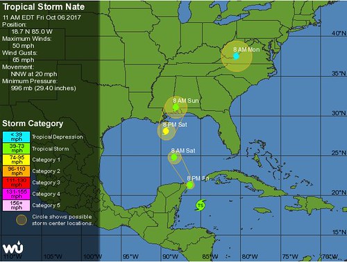
They really are hitting everybody this year. And it seems like they know just where to hit everybody too. Nate is forecast to come onshore as a fast moving and weak category 1 storm. Under most circumstances that's pretty good. But in our case, really, the fact that it's coming at all is a problem.
You may have heard about this drainage issue, for example.
With the Sewerage & Water Board’s drainage system improved but still at diminished capacity in the wake of the Aug. 5 flooding, and facing the possibility of a direct hit by Nate, Mayor Mitch Landrieu declared a state of emergency for the city.He's right about that one. To illustrate the point, yesterday our hurricane supply shopping list included a bottle of whiskey and a variety of beers. (We've got some Abita Pecan, some Miller Lites, and the Tin Roof with the LSU themed cans.) We aren't even planning to remain dry during the storm. By the way, one of the odd things I noticed during Tuesday night's mayoral debate was Michael Bagneris's stated vision of "a dry city." It raised all sorts of red flags.
City agencies are readying for the storm but also telling residents to be prepared for flooding in some areas.
“When you get 5 to 10 inches of rain in two or three hours, you’re going to expect to see some flooding,” regardless of how many pumps are operating, Landrieu said.
“An expectation of being dry 100 percent of the time when you live in New Orleans is not a reasonable expectation,” he added.
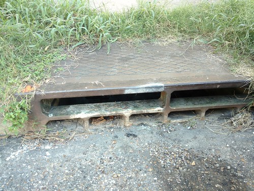
In any case, we're probably not going to get that much rain. Especially if the storm moves through as quickly as they're anticipating and if the track takes the easterly jog predicted as of this morning. We're frantically cleaning our storm drains just to be on the safe(r) side. That's good to know because, after the summer we've had, nobody is in any hurry to test the pumping system.
As of Thursday, 108 of the 120 pumps that form the heart of the city’s drainage system were working. That’s four more than were working on Aug. 5."Theoretical maximum capacity" is a thing because of the continuing power limitations. It's not only a function of how many pumps are in working condition. It's also about how many can be safely powered at one time.
Eight of the ones out of commission are the large drainage pumps used during storms, while four are small “constant duty” pumps only used for light rains.
As a result, eight of the 24 pump stations across the city are at between 50 percent and 96 percent of their theoretical maximum capacity, according to information from the S&WB.
With three of its five turbines operational, the S&WB’s Carrollton power plant is now capable of producing or converting 39.25 megawatts of 25-cycle power, a standard used by about half the pumps in the city. Another 11 megawatts of the more standard 60-cycle power — used by the rest of the pumps — is available from 26 generators.If Johnese Smith were here she'd tell us a story about Captain Kirk yelling at Scotty to get him more power to the warp drive or something like that. Maybe that's what these guardsmen will be there to do.
But that is not enough for the S&WB to run all its pumps at once, meaning officials could have to pick and choose where to direct power during a citywide storm. Logs from the Aug. 5 flood suggest that S&WB officials delayed turning on at least one pump station because power was not available.
Interim management team member Paul Rainwater cited the complicated dance the utility goes through during every storm to route power where it’s needed most and said of the pumps, “You don’t turn them on and run them full throttle all the time.”
There are actually more pumps to account for now than during this summer's thunderstorms. For the first time this year, the pumping capacity along the outfall canals will probably come into play. What kind of shape are they in? Who even knows? You may also be curious, given the unusual speed at which Nate is approaching, how far along we are in the complicated process of closing the surge protection system altogether.
In short, at the pumps and at the gates, we've got some carefully choreographed complicated dances going on to either power the pumps or seal off gaps in the system. Ordinarily that might very well be reason to worry. Given the forecast, it looks like we'll probably be more or less okay. But, yes, by all means please be prepared to make whatever decision is the most prudent for you and your family. Beignet Fest can wait, you know.Anyone can see which gates are open or closed by using the Levee Information Management System, a software program created by the Southeast Louisiana Flood Protection Authority-East.All of them must be closed as a storm approaches the region. Even that isn’t simple, because those closures must follow a complicated procedure spanning 96 hours and involving personnel from more than 10 local, state and federal agencies, as well as the maritime industry. And because the plan must account for changes in tide and wind predictions, it has twists and turns that can make it look like a Rube Goldberg creation.It all results in a complicated dance in which a misstep could result in parts of the city getting very wet.“It is carefully choreographed,” said Bob Turner, the engineer who is the regional director of the Southeast Louisiana Flood Protection Authority-East.“It’s somewhat unique in that the things you have to do in order to mitigate flood risk don’t always have strictly to do with flood control.”
No comments:
Post a Comment